Scotland's Loch Village: Black Loch of Myrton
Excavations at Black Loch of Myrton in Dumfries and Galloway in 2015, 2016 and 2017 have yielded stunning new information about life in the Iron Age. Our work has focussed on very well preserved early Iron Age settlement which was located on the fringes of a boggy loch, long since drained.
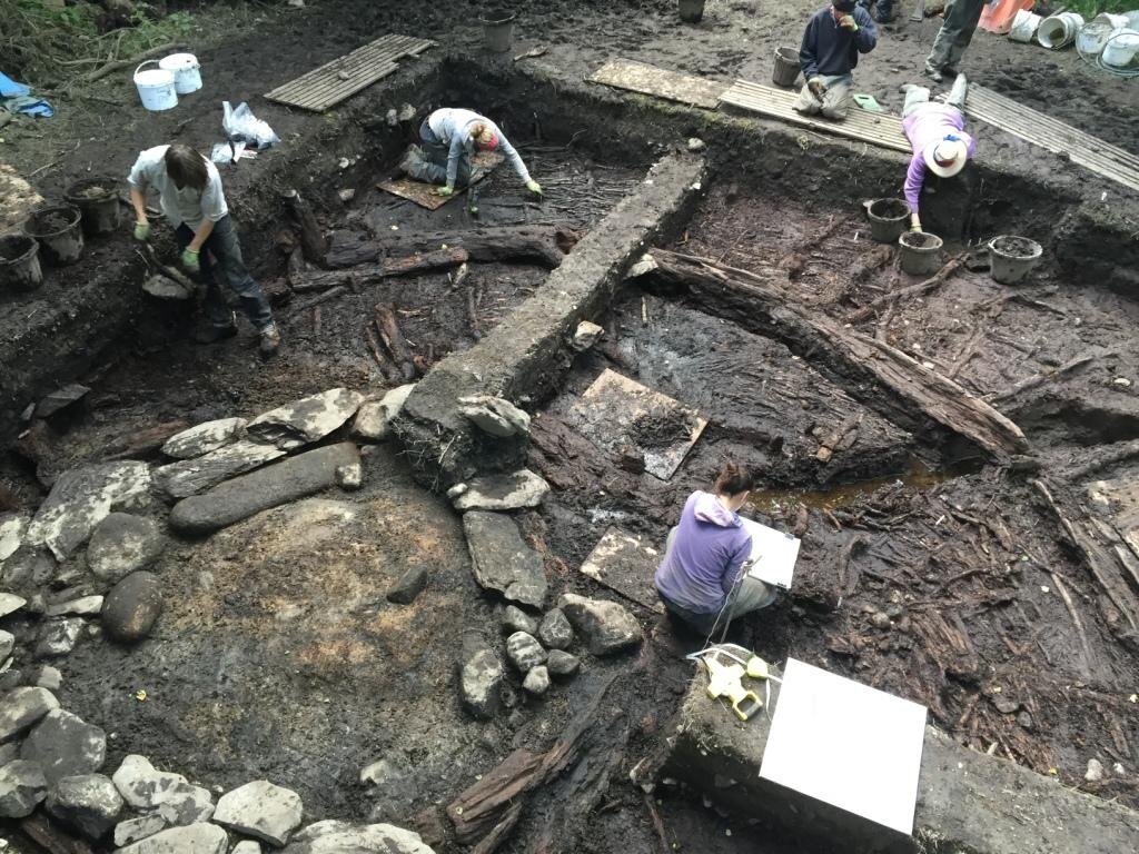
In 2015, excavations targeted one of the many large mounds identified on the site. This was found to be a stone and timber hearth setting, over 2.5 m square, located at the centre of a timber roundhouse c. 13m in diameter. The hearth had been refurbished at least three times by adding a new layer of cobbles, clay and timber on top of the previous hearth base. Associated with the hearth was a sequence of flooring deposits comprising reeds, wicker panels and clay spreads, again showing evidence for repeated refurbishment. The wall of the roundhouse was found to comprise a double ring of stakes, around 30 cm apart. In the better-preserved areas of the outer wall, woven withies survived in situ to a height of around 20cm from ground level. In the area where the walls approached the entrance to the house, the wicker walling was replaced by vertically-set oak planks, forming a façade-like outer face. The entrance of the roundhouse was located and excavated in 2016, and was remarkably well preserved. Like the central hearth, the entrance structure had been refurbished at least three times. The lowest levels were in very good condition, and comprised several dressed logs showing evidence for jointing and dowelling. Two 'sleeper' beams were jointed with sockets, presumably for vertical posts at the terminals of the roundhouse wall. Provisional radiocarbon dates from the occupation deposits in this structure indicate a mid-1st millennium BC date for its occupation.

Excavations near the perimeter of the settlement in 2016 located evidence for several phases of enclosure, the earliest of which comprised a closely-set palisade of alder logs (above left) c.25cm in diameter, and the latest of which may have been a heavy stone wall. Within the early perimeter, beneath the later stone wall, the remains of two clay structures were discovered, interpreted as cooking ovens (above centre and right). These structures were very similar in design, comprising a clay dome, probably supported by a wicker basket-like structure – still preserved in the earlier example – over a base of flat greywacke slabs. In the later oven, remains of cooking debris was recovered from the oven base and contained large quantities of hazel-nut shells, burnt bone and marine mollusc shell. The ovens were probably located within a building, and were associated with compacted reed floor deposits similar to those encountered within the roundhouses on the site. However, excavations in this area were too limited in extent to elucidate the form of this structure.
One of the objectives of 2017’s fieldwork was to determine the extent, nature and complexity of the defensive perimeter around the settlement. The excavation revealed a series of wooden palisades and an earthen rampart which run around the edge of the island and terminate on either side of the causeway.
The earliest defensive line in the stratified sequence was a stake-and-wattle fence. This was replaced by a similar fenceline behind which the remnants of a low earthen bank were found. This earthen bank had been cut through to construct a later palisade consisting of a slot into which large flat-based oak posts had been inserted and packed around with edge-set slabs and boulders. An earthen rampart, 0.3m high and 1.9 m wide was built up behind the oak post palisade and topped with a cobbled surface.
The outermost defensive line was a palisade of massive vertically-set oak planks. The line of this palisade was tracked around the S edge of the island in a series of slot trenches. It terminated at the point where an alder post palisade found in Tr6 in 2016 begins. The oak plank palisade cannot be stratigraphically related to the sequence outlined above because it lies some 3m outside the oak post palisade in the loch sediments.
A trackway ran across the causeway, between the terminals of the palisades and rampart, and on into the interior of the settlement. The outermost section of the track, up to the point where it met the oak post palisade and rampart, consisted of tangentially-laid oak planks and was flanked by a post-built wall and short bank which terminated at the junction with the oak post palisade. Beyond this point the construction of the trackway changed to one of brushwood bundles, each layer being laid at right angles to the one below. The trackway was 1.9m wide. The brushwood section was refurbished at least once, again with brushwood bundles, and was finally capped by a cobble surface.
Evidence for earlier activity was found beneath the rampart. This consisted of a thick deposit of unburnt hazelnut shells, some 0.37m thick, which sealed two horizontally-laid hurdle screens. Other features beneath the rampart included a rough alignment of stakes and a line of posts; all these features were uncovered in a relatively restricted area and consequently, it is currently unclear as to what they represent.
A further trench was excavated over a low stony bank, associated with an area of high resistance identified by geophysical survey. This trench uncovered evidence for the stone platform or trackway encountered in excavations in 2016. Beneath this stony layer and sealed by a thick charcoal layer was evidence for a building, possibly a roundhouse, with a central stone hearth. This hearth had been refurbished at least once in a similar manner to those encountered elsewhere on the site, and was associated with a wicker sub-floor structure and layers of laminar reed flooring. Evidence for an earlier phase of enclosure of the settlement was found directly beneath this building, in the form of heavy palisade of alder posts, averaging 0.30m in diameter. These posts were set in a deep slot cut into the natural peat, and were preserved to over 1.5m in length.
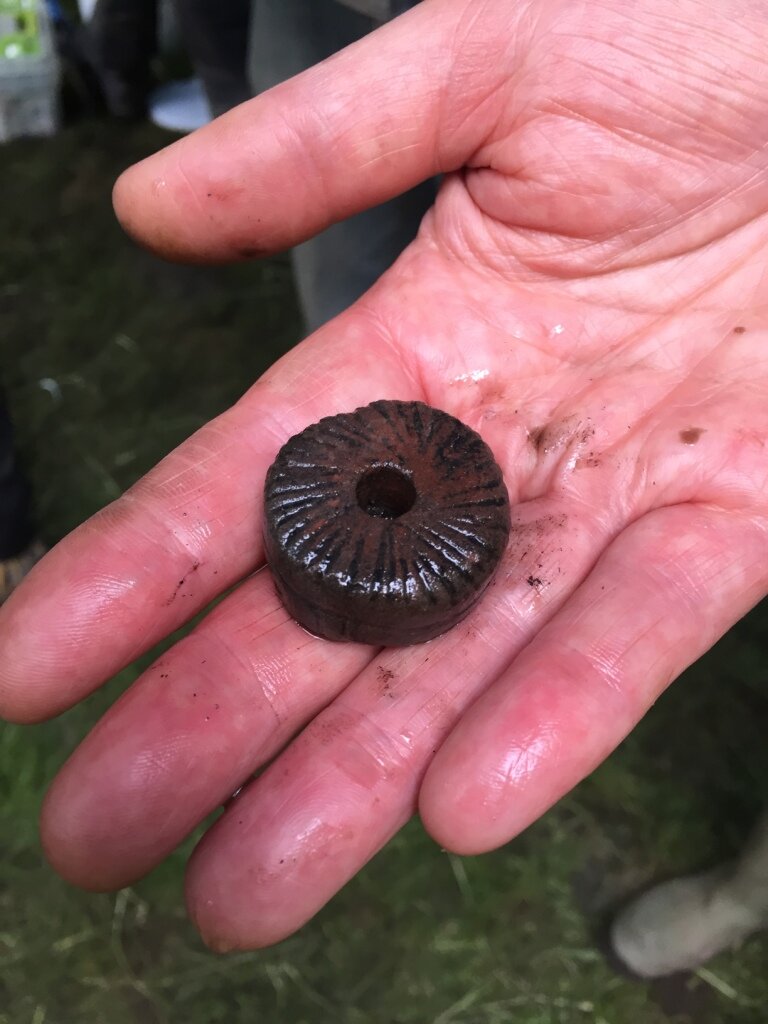
Artefacts were limited in number and variety from all seasons of excavation. However, a large number of stone tools were recovered, including querns, rubbers and grinders, as well as a small clay 'thumb pot'. A decorated stone spindle whorl (right) was recovered in 2016.
Excavations at Blach Loch of Myrton are carried out by AOC’s archaeologists along with volunteers, who receive training, guidance and much gratitude in return for their hard work in very muddy conditions!
Excavations at Black Loch of Myrton have been made possible thanks to support from Historic Environment Scotland.
You can watch a number of short films about our work at Black Loch of Myrton on Vimeo.