
Archaeological Survey on the National Forest Estate
AOC HAS CARRIED OUT A WIDE RANGE OF SURVEYS ON THE NATIONAL FOREST ESTATE ON BEHALF OF FORESTRY COMMISSION SCOTLAND
Caring for Scotland’s archaeological sites and monuments located on actively planted forestry land is a huge challenge for the Forestry Commission’s managers. FCS have commissioned AOC to undertake condition and management surveys of sites and monuments in a variety of locations, providing baseline data and management recommendations for known monuments, or prospective survey for new discoveries prior to new planting. AOC’s survey team have developed procedures and methods suited to working in remote areas with restricted access, tailoring survey approaches to ensure a high quality result.
Forestry Commission Scotland is committed to developing new approaches to recording heritage assets on the NFE, and worked with AOC to apply new technologies and new techniques for the visualisation and depiction of archaeological survey data. Key to these approaches has been the use of 3D laser scanning, a technique ideally suited to creating detailed records of upstanding monuments, for the extraction of 2D interpreted drawings and for integration with other survey techniques, such as geophysical survey.
Previous Surveys

Caisteal Grugaig
Among the sites for which AOC has been asked to produce surveys are several brochs and duns of the north and west Highlands. At Caisteal Grugaig, 3D survey throughout the structure allowed the extraction of cross-sections through the surviving stonework, as well as an innovative ‘unrolled’ projected view of the interior stonework.
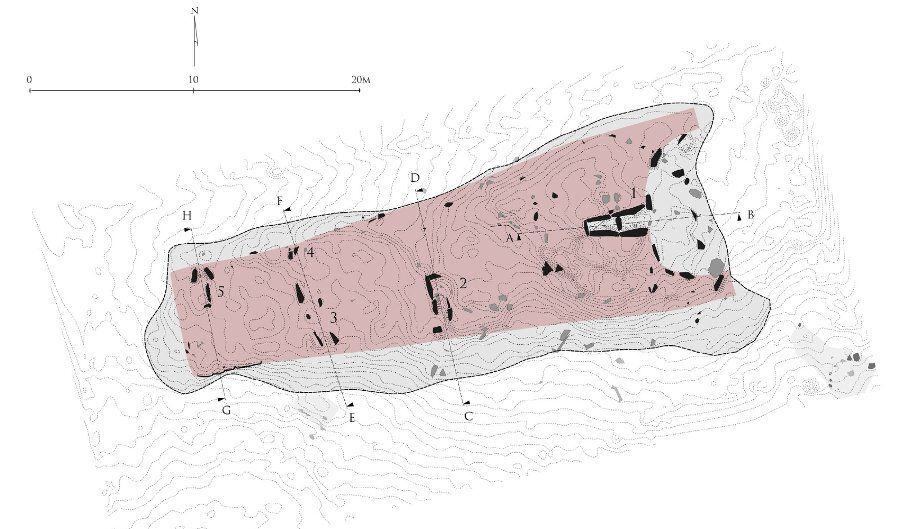
On Arran, AOC worked with FCS and other contractors to develop new approaches to the survey and analysis of chambered cairns. In a major survey of ten monuments, 3D data was used to provide baseline surveys and structural analysis that can be used for ongoing monitoring and management. The survey and visualisation techniques have since been applied to other cairns, such as Gort Na H'Ulaidh in Kintyre.
Gort Na H'Ulaidh, Kintyre

Giants' Graves 2, Arran
At Ormaig, high resolution (sub-mm) laser scanning and photogrammetric tecniques were used to provide a condition survey of the spectacular cup-and-ring marked rocks. The data was compared to an earlier laser scan, carried out in 2007 prior to the removal of conifers from around the site, and differences mapped.

Ormaig Rock Art, Knapdale
Cracknie souterrain, a remote prehistoric underground passage, presented a particular challange for survey. Only accessible via a walk over rough moorland and by squeezing through the narrow entrance, detailed survey using any traditional means would have been very difficult. Laser scanning was used to produce 3D models and detailed, stone-by-stone elevations and cross-sections.

Many of the surveys carried out on behalf of the Forestry Commission have been used to compile guidance notes for land managers and operatives working on the National Forest Estate, as well as to produce educational and outreach materials.
Find out more about Scotland's woodlands and the Historic Environment here.
In association with:


